
Being neighbour to the ever-popular Castle Rock Granite Skywalk and just 30 minutes away from the Stirling Ranges, it feels as though the Nancy Peak and Devils Slide hike is often overlooked. Way down on the list for adventurers who head to the Great Southern region just to tackle Bluff Knoll or climb the Granite Skywalk. The lack of attention the Nancy Peak and Devils Slide hike receives doesn’t reflect how incredible this hike is. It’s undoubtedly the most underrated hike in the region and has quickly become one of our favourites.
We’ve decided to put together this guide on everything you need to know about the Nancy Peak and Devils Slide hike to encourage more people to take it on. We’ve put together information on everything you need to know; from how long it is, how high each of the peaks are, how hard the hike is, what fees are required, what facilities are at the trails, plus more. Just keep reading to fully prepare yourself for the spectacular Nancy Peak and Devils Slide hike.
How Long does the Nancy Peak and Devils Slide Hike Take?
The full return hike takes around 3-5 hours on average. This will vary depending on your fitness levels, how many rest stops you take and whether you’ll be stopping and taking photos along the way.

How Long is the Nancy Peak and Devils Slide Hike Trail?
We recorded the full trail to be 7.58km return, this includes the full Nancy Peak Circuit Trail (returning via Wansbrough Walk) and the Devil’s Slide Trail.
Typically when going on a hike we wouldn’t track the length and would just base it off the trails reported length on the map of the trail. However, the trail is split into 3 different sections; the Nancy Peak Circuit Trail, the Devil’s Slide Trail and the Wansbrough Walk which made it difficult to find a total length of all 3. When calculating it manually through adding up the different trail lengths shown on the signposts it comes out to 7.2km – based on adding the Nancy Peak Circuit Trail returning via Wansbrough Walk at 5.5km, adding Devil’s Slide at 5km return including the Wanbrough Walk and removing the Wansbrough Walk distance of 3.3km return (since the Nancy Peak Circuit Trail distance already includes the Wansbrough Walk).
Even when researching the trail every website we looked at seemed to report a different length with majority saying it was below the 7km mark at 6.4km or 6.7km return. We were surprised when it surpassed these and came out to 7.58km.

How High is Nancy Peak?
Nancy Peak sits 652m above sea level.
How High is Devils Slide?
Devils Slide is the Porongurup Range’s highest peak. Devils Slide sits at 670m above sea level.

What Grade is the Nancy Peak and Devils Slide Hike?
The Nancy Peak portion of the hike is classified as a grade 4 trail. Grade 4 trails are recommended for experienced hikers as grade 4 trails are typically long, rough and very steep.
The Devils Slide portion of the hike is classified as a grade 5 trail. Grade 5 trails are recommended for highly experienced hikers as grade 5 trails are very rough, very steep and rock scrambling can be required.
How Hard is it to do the Nancy Peak and Devils Slide Hike?
With two peaks to climb at very steep inclines on an uneven and overgrown path, the Nancy Peak and Devils Slide hike definitely isn’t a walk in the park, it would be classed as a difficult hike. However, it’s a very achievable challenge for people with a good level of fitness. Just know your limits and take rests as often as required.
As we’ve discussed in more detail further down in this post, the path can be very steep and rugged at times meaning you’ll have to climb up steep rocks and occasionally squeeze in between small gaps, we’ve tried to show this in the images below. You will need some agility to comfortably navigate your way through these sections. It would also make the hike difficult for anyone with knee or leg issues.


When is the Best Time of Year to do the Nancy Peak and Devils Slide Hike Trail?
The Nancy Peak and Devils Slide trail can be done all year round, however the best time to complete the hike is during spring (September-November). The spring months typically bring the best weather conditions, as it’s not too hot (as it can be during the summer months) and isn’t too rainy or slippery (as it can be in the winter months). The Porongurup National Park also comes alive during spring with vibrant wildflowers that light up the park and give it a magical feel.
With that being said, we completed the hike during summer in January and the conditions were perfect. We went on a partly cloudy day and to combat the heat we arrived early in the morning and started the hike around 5-6am. By the time we were finishing up the hike it was starting to get hot as the trail is not shady or protected from the sun, reminding us the importance of starting the hike early during Summer! We also still came across a number of stunning wildflowers throughout the trail.


When is the Best Time to Hike Nancy Peak and Devils Slide?
You can start the hike at any time, the best time to start however depends on what time of year you’re visiting. If you’re visiting during Summer we’d recommend starting the hike early in the morning (between 5am and 9am) to avoid the unbearable summer heat that comes along by midday.
Due to how steep and rough the path is it could be dangerous to hike outside of daylight hours if you have no prior experience doing so. Therefore, if you’re hiking early in the morning make sure to check what time sunrise is at the time you’re visiting as it varies significantly depending on the month.
What Should I Expect on the Nancy Peak and Devils Slide Hike?
Imagine being inside a terrarium? That’s what the Nancy Peak and Devils Slide hike is like. After seeing someone on Tripadvisor compare the hike to the inside of a terrarium we can’t help but agree. The Nancy Peak and Devils Slide trail is an extremely rewarding and varied trail. With every 100 metres you almost feel like you’re on a completely different trail.
Starting off the hike, just 100 metres in you reach the Tree-in-the-Rock, a popular natural attraction where a large tree is growing on top of a granite boulder. A unique example of what nature can do.


The trail from here is mostly undercover with rocky steps up to Nancys Peak. Just a short distance after the Tree-in-the-Rock is another natural phenomenon, a large tree with a large hollow centre the size of a person. It’s another spectacular sight that makes for a great excuse to take a break before continuing the hike up the mountain.


The trail continues to get steeper and rockier as you make your way up the mountain. But there’s always something new to look at along the trail as you now pass a large fallen tree.


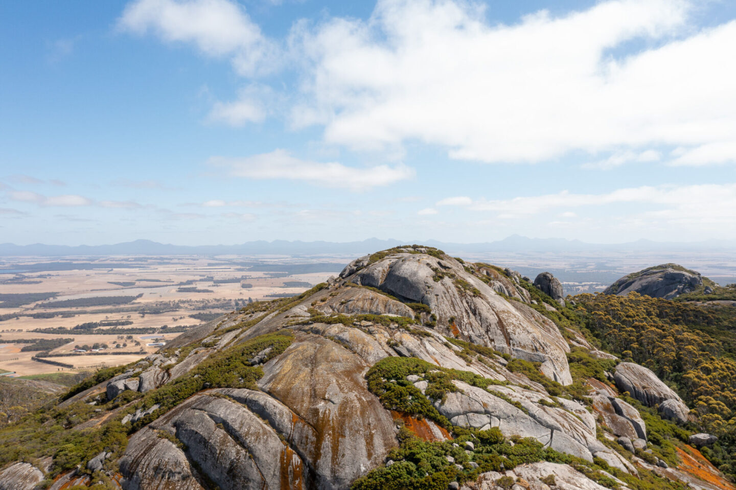
Just before your first lookout point the path opens up into a larger and flatter path with few surrounding trees. The first lookout point (Hayward Peak) is set on a large granite boulder where you get your first look at the incredible views of the surrounding countryside, you can even see the Stirling Range off in the distance and the Bolganup Dam below.

After the large open space on the granite boulder, the path gets steeper and rockier again with sections where the path is extremely skinny and overgrown. Once you make it through these you’ll reach the summit of Nancy Peak which is a large open area of granite boulder. The large open area makes it hard to distinguish where the summit of Nancy Peak is, particularly as there’s no markers to let you know. Just look around and once you’re at the highest point of the mountain you’re there.

As you leave the summit of Nancy Peak you’ll start to see Devils Slide in the distance. You’ll go down a steep and rocky decline down Nancy Peak.
The trail will then start to flatten as you approach the start of the Devils Slide ascent and this was one of the most magical sections of the trail. Along the floor were hundreds of butterflies camouflaged amongst the fallen leaves, as we approached them they would fly up in the air around us. There’s no way to truly capture the beauty of this experience, it was something you had to witness in person to truly appreciate. Enjoy our attempt at trying to capture some of the butterflies below, the picture on the left we just managed to catch a butterfly flying off and in the picture on the right you’ll need to look carefully to see a butterfly camouflaged on the ground.


The start of the incline up Devils Slide can feel disheartening as you feel like you’ve come back down the elevation you worked so hard to hike up getting to Nancys Peak. You’re quickly distracted though by the varied terrain of Devils Slide. You end up hiking up a steep rocky incline where the path gets extremely thin and overgrown, becoming more like rock climbing than a set path. However the deeper you go the more you’re rewarded with stunning greenery and wildflowers that surround you.


The final stretch to Devils Slide includes crossing a short wooden bridge and climbing up a few extremely steep sections of granite boulder.
There’s one point on the granite boulder where we felt we may have gone as far as we could until we saw a trail marker on top of a very steep section, we then realised we had to climb it and still had a way to go.


At the top of Devils Slide you’re once again rewarded with incredible 360 degree views around you.
After spending some time enjoying the summit of Devils Slide you’ll make the steep decline back, being significantly faster than you were on the way up but also needing a great deal of caution as you try not to slip on the steep path and loose rocks. At the bottom of the steep decline you’ll have a relatively short stretch of wide open trail back to the Tree-in-the-Rock car park. The path is made up of loose gravel and rocks making it slippery at times.
Are there any Fees at the Nancy Peak and Devils Slide Hike?
Yes, park entry fees are required for the Porongurup National Park which the Nancy Peak and Devils Slide hike is located in. At the time of writing this (January 2023) the price is $15 per standard vehicle (with 12 or less occupants). Once purchased, put the pass on your dashboard so it’s visible through your vehicles window. The fee collection station is located on the road leading to the Tree-in-the-Rock day use area.
If you’re visiting multiple national parks during your trip we would recommend getting a holiday pass or an annual all parks pass as these will be better value for money. Holiday passes are available for 5 days, 14 days or 4 weeks and annual all parks passes are available for a full year. You can buy these online (here) on the Department of Biodiversity, Conservation and Attractions website.
Is there Parking at Nancy Peak and Devils Slide?
Yes, the Tree-in-the-Rock day use area where the Nancy Peak and Devils Slide trail starts has a large carpark. The carpark is currently unsealed, but was in good condition and relatively flat so was still suitable for our 2WD Mercedes Sprinter to park in. The car park doesn’t have marked designated bays but would fit 20-30 cars.
A large sign was located outside the car park sharing information on the planned redevelopment, which they said will be finished in 2024. With this redevelopment the carpark will be sealed and will have designated bays. We look forward to seeing what they do with the area.

Is the Road to the Nancy Peak and Devils Slide Hike Sealed?
Yes, Bolganup Road (the road that leads up to the Tree-in-the-Rock day use car park) is sealed, making it suitable for all vehicles to drive on. The car park itself is unsealed gravel but was suitable for our 2WD Mercedes Sprinter to park in.
Are there Toilets at the Nancy Peak and Devils Slide Hike?
Yes, there is a toilet block at the Tree-in-the-Rock day use area at the start of the Nancy Peak and Devils Slide hike trail. The toilet block has a mens section and a women’s section, each of which have 2 drop toilets and a sink. The toilet blocks were clean and well maintained when we visited.

What Other facilities are at the Nancy Peak and Devils Slide Hike?
Besides a toilet block, the Tree-in-the-Rock day use area also features 2 barbecues, 1 undercover picnic area and lots of picnic benches. All of which make it the perfect spot for a picnic after your hike.
During our visit the barbecues looked clean and well maintained.

Do you Need a Map for the Nancy Peak and Devils Slide Hike Trail?
No you do not need a map to complete the Nancy Peak and Devils Slide hike trail as it’s relatively easy to navigate through.
The starting point for the Nancy Peak circuit is clearly signposted on the left side of the Tree-in-a-Rock day use area, close to the car park. Once on the trail it is obvious where to go as the path is quite clear. Even in spots where the path becomes quite skinny or is overgrown it’s usually still obvious where to go as the surrounding area is covered in bushland and shows no signs of an alternative route. There are trail markers along the trail to reassure you that you’re on the right path but unlike trails such as Castle Rock or Bluff Knoll, the trail markers don’t give you an idea of remaining distance.


Where does the Nancy Peak and Devils Slide Trail Start?
The trail starts close to the Tree-in-the-Rock day use area. Upon arriving at the car park, the start of the trail is to the left and is clearly signposted with ‘Nancy Peak Circuit’.

Where is the Nancy Peak and Devils Slide Hike Trail?
The Nancy Peak and Devils Slide hike trail is located in the Porongurup National Park in Porongurup, within the Great Southern Region of Western Australia.
How do you Get to the Nancy Peak and Devils Slide Hike Trail?
There is no public transport nearby so you will need to drive to get to the Nancy Peak and Devils Slide trail. The trail starts from the Tree-In-The-Rock day use area so make sure to navigate there (Google Maps link is here).
How Far is the Nancy Peak and Devils Slide Hike from Perth?
The Nancy Peak and Devils Slide hike is approximately 393km from Perth, which is about a 4.5-5 hour drive away (depending on traffic and which route you take).
How Far is the Nancy Peak and Devils Slide Hike from Albany?
The Nancy Peak and Devils Slide hike is approximately 51km from Albany, which is about a 40-60 minute drive away (depending on traffic and which route you take).
What Should you Wear When Doing the Nancy Peak and Devils Slide Hike?
Wear flexible and breathable clothes that you are comfortable hiking in. We would recommend wearing multiple layers that can be adjusted if the weather changes or as you heat up. There are sections where the path is overgrown so we would recommend covering up and wearing long clothing as leaves and twigs will scratch your legs and arms otherwise.
The trail can be steep and slippery at points so make sure to wear grippy and comfortable footwear, such as trainers or hiking boots.
As with any hike, make sure to stay sun smart even on overcast days; wear a hat, cover up and put sunscreen on.


What Should you Pack When Doing the Nancy Peak and Devils Slide Hike?
We would recommend packing the following for the Nancy Peak and Devils Slide Trail:
- Water – 1L per person per hour is the recommended amount to take.
- Food – make sure to pack some snacks so you can refuel along the way. If you’d like to stay for a picnic after the hike make sure to also pack lunch.
- A first aid kit – we always recommend packing a first aid kit no matter the length or difficulty of the hike. It’s better to be safe than sorry.
- A hat and sunscreen – protect yourself and stay sun smart.
- A camera – either pack a camera or use your phone to take pictures of the incredible views at the top of Nancy Peak and Devils Slide.
Are there Any Other Trails in the Area?
Yes, the Great Southern Region has an abundance of incredible hiking trails in both the Porongurup Ranges and the nearby Stirling Ranges.
If you’ve finished the Nancy Peak and Devils Slide hike and would like to take on another hike from the Tree-in-the-Rock location there is one other trail here, known as the Bolganup Trail. The Bolganup Trail is a short 600 metre return loop that takes you through the towering Karri trees to Bolganup Creek before returning to the Tree-in-the-Rock picnic area. As a short and flat grade 2 trail, this one is perfect for the whole family to enjoy.
The super popular Castle Rock Granite Skywalk trail is neighbour to the Nancy Peak and Devils Slide hike. Just a 10 minute drive away from the Tree-in-the-Rock day use area, this hike is 4.4km return, taking around 1.5-2 hours on average. Anyone with a can-do attitude can make it to the lower lookout of the Castle Rock hike but making it to the Granite Skywalk requires a rock scramble and climbing up a 7 metre ladder. If you do so, you’ll be rewarded with spectacular 360 degree views around you. If you’d like to learn more about the Castle Rock Granite Skywalk hike make sure to check out our post: Granite Skywalk Castle Rock: Everything You Need to Know.
If you’d like to take on the challenge of the famous Stirling Ranges you can make the 30 minute drive out to enjoy one (or multiple) of the six different mountain trails. Each mountain trail makes for a completely unique experience, spectacular in their own right. The six trails are the Bluff Knoll summit trail, Talyuberlup Peak trail, Mount Hassell hike, Mount Magog trail, Toolbrunup Peak trail and Mount trio Trail.
Enjoy the Nancy Peak and Devils Slide Hike
That’s our full guide on everything you need to know about the Nancy Peak and Devils Slide hike. We hope you enjoy the Nancy Peak and Devils Slide hike and the Porongurup Ranges as a whole!

Hey! I’m Lydia and I have been travelling full time with Wehan since 2022. Alongside documenting our travels on YouTube, we put together comprehensive travel guides on the locations we visit here on our website. We also put together guides on other aspects of our travels, such as detailed information on the gear we use, specifics on our van build and tips for van life. Our goal with this website and the guides we write is to help others travel.
At the moment we are currently doing the big lap of Australia in our self converted Sprinter van. Our goal is to continue to push ourselves outside our comfort zone; seeking new adventures, learning about new cultures and seeing as much of the world as possible.
