
Without a doubt the hardest mountain trail of the Stirling Ranges, the Toolbrunup Peak walk is a fun challenge for adventurers and thrill-seekers. With stunning landscapes, near vertical climbs up loose rock and spectacular views at the summit, you won’t be disappointed by Mount Toolbrunup.
This guide will help you prepare for the Toolbrunup Peak walk, sharing everything you need to know about the Toolbrunup Peak walk so that you can conquer it. We share details such as; how long the Mount Toolbrunup walk is, how hard the Toolbrunup Peak walk is, the best time to take on the Toolbrunup Peak walk, how much the Toolbrunup Peak walk costs and what facilities are at Mount Toolbrunup.
How Long is the Toolbrunup Peak Hike?
The Toolbrunup Peak hike is approximately 4km return.
How Long does it take to Climb Toolbrunup Peak?
The Toolbrunup Peak hike takes around 3-5 hours to complete. The time it takes you will depend on how often you stop to rest, how long you spend on the summit and your fitness level.
How High is Mount Toolbrunup?
Mount Toolbrunup has a height of 1052 metres above sea level.

Is Mount Toolbrunup the Second Highest Peak in the Stirling Range?
Yes, Mount Toolbrunup is the second highest peak in the Stirling Range. Mount Toolbrunup is just 43 metres shorter than Bluff Knoll which is the highest peak in the Stirling Range.
What Grade is the Toolbrunup Peak Hike?
Toolbrunup Peak is classified as a grade 5 hike. A grade 5 hike is only recommended for very experienced bushwalkers as grade 5 trails can be long, unmarked, very rough and very steep. They also may require rock scrambling.
Talyuberlup Peak and Mount Magog are also grade 5 hikes however Toolbrunup Peak is without a doubt the hardest mountain trail of the Stirling Range and would be considered harder than Talyuberlup Peak and Mount Magog.
How Hard is it to Hike Toolbrunup Peak?
Definitely the hardest trail of the Stirling Range, it’s safe to say that the Toolbrunup Peak walk is a hard hike. The grade 5 rating holds true to Toolbrunup Peak which is a rough and steep path that requires a considerable amount of rock scrambling.
Almost immediately the trail becomes loose rock, which is particularly difficult to hike up when you’re on an incline and the rocks are slipping underneath you. You’ll eventually reach a massive near vertical rock scree that you have to climb. You’ll have to climb with multiple points of contact up the rock scree being careful not to stand on loose or wobbly rocks.


Can Anyone Hike Toolbrunup Peak?
Yes, anyone with a high level of fitness and agility (and determination!) should be fine to do the hike. Just be aware of your own limits, listen to your body and take your time.
The hike would not be suitable for anyone with knee or leg issues as the loose rock is particularly demanding on your joints.
Can Kids do the Toolbrunup Peak Walk?
Yes kids can do the Toolbrunup Peak walk however the walk would not be suitable for very young kids and would only be suitable for older kids who have experience taking on difficult hikes.
Can Elderly People do the Toolbrunup Peak Walk?
Yes, older people can take on the Toolbrunup Peak walk. However, as mentioned before, we would not recommend anyone with knee or leg issues take on the walk as the loose rock is particularly demanding on your joints.
We would also recommend you only take on the Toolbrunup Peak walk if you are agile and have experience taking on difficult hikes.
Can you do the Toolbrunup Peak Walk Solo?
Yes you can do the Toolbrunup Peak walk solo if you want to. On the day of the hike we recommend letting someone know that you’re doing it and approximately how long you expect it to take.
When is the Best Time of Year to Climb Mount Toolbrunup?
The Toolbrunup Peak walk can be done any time of year. The best time to complete the hike is typically during spring (September-November) as this is when the Stirling Range National Park lights up with vibrant wildflowers and when the weather conditions are the best. Spring typically avoids the intense heat that summer brings and the wet and windy weather that comes with winter.
We would not recommend doing the Toolbrunup Peak walk during bad weather. If raining or windy the trail can be dangerous.
We did complete the hike during summer in January and the conditions were perfect for us. We watched the weather forecast prior and made sure to take on the Toolbrunup Peak walk on a partly cloudy day so we’d be kept cool but would still have great views on the summit. If it’s too cloudy you won’t get any visibility at the summit. The trail also still had a lot of flowers during January.


What is the Best Time to Hike Mount Toolbrunup?
You can do the hike at any time, the best time to take it on will depend on what month you’re visiting. We’d recommend starting the hike at a time that is cool but you still have great visibility. If you’re visiting during Summer for example, this would be early in the morning (between 5am and 9am) when the sun has risen but you’re still able to avoid the intense summer heat that comes along by midday.
Sunrise and sunset hikes are popular in the Stirling Ranges but it is dangerous doing the Toolbrunup Peak walk in the dark. The trail markers on the rock scree are easily visible during the day but would be difficult to see and safely navigate through in the dark. We definitely wouldn’t recommend doing a sunrise or sunset hike if you’ve never done Toolbrunup Peak before. If you are going to do the Toolbrunup Peak walk at sunrise or sunset, being familiar with the walk (and having done it in the past) will help, also make sure to take a torch and don’t do it alone or let someone know that you’re doing it and how long you expect to be.
As noted previously, make sure to keep an eye on the weather forecast to help find the best time to do the Toolbrunup Peak walk. For example, we took on the hike during the day in summer which we wouldn’t usually do as it would be too hot but we did it on overcast day so the conditions were perfect.

What Should I Expect on the Toolbrunup Peak Hike?
Expect a very challenging hike up a steep trail of loose rock and near vertical climbs up massive rock screes. The trail starts off as a relatively flat dirt path through lush green forest. Almost immediately loose rocks begin to appear on the trail and they quickly take over as the trail is entirely loose rock from here on out.


This portion of the trail is quite shaded by the surrounding trees and follows a small creek. It’s also where we saw a lot of wildlife along the trail. We saw multiple skinks sunbathing on the rocks and a few caterpillars.


Despite being relatively flat at the start, the trail quickly gets steeper and steeper. While the incline isn’t too bad, the steep sections are frustrating to hike as the trail path is entirely loose rock. You’ll constantly have to be conscious of where you step as the rocks slip underneath your feet. Soon enough you come face to face with your first rock scree and what a sight it is! You’ll have a take a moment to stare at it in disbelief. The rock scree looks out of place, almost as if the thousands of rocks have been purposefully dumped down the side of the mountain.


After crossing multiple rock screes you’ll then face the first rock scree that you have to climb. There’s no way to accurately explain or photograph the rock scree. You really just have to see it to believe it. The rock scree is massive. Look up and you’ll spot trail markers all throughout the scree. Starting the rock scree you’ll have to be conscious of where you step, being careful not to stand on very loose rocks and using multiple points of contact to keep yourself stable. Despite being difficult the rock scree is actually pretty fun.
We’ve included a drone photo of a small portion of the rock scree below. Look carefully enough and you’ll see the teeny tiny trail markers amongst the scree.

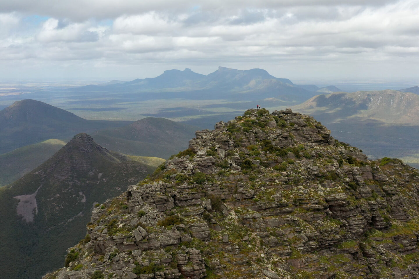
After what feels like forever and endless near vertical rock screes you’re faced with a section of steep rock scrambling to reach the summit. The summit itself is very skinny with not much room to explore but you’ll have spectacular views as you tower over the nearby peaks of the Stirling Range.
Take some time to enjoy the summit and recover before making your way back down. Take the return trip slowly to make sure you don’t slip on the loose rocks (scooting on your butt becomes a ‘must’ to help prevent any falls).

How Much does it Cost to Climb Mount Toolbrunup?
There is a park entry fee for the Stirling Range National Park which the Toolbrunup Peak walk is within. At the time of writing this (March 2023) the price is $15 per standard vehicle (with 12 or less occupants).
If you’re visiting multiple national parks during your trip we would recommend getting a holiday pass or an annual all parks pass as these will be better value for money. Holiday passes are available for 5 days, 14 days or 4 weeks and annual all parks passes are available for a full year. You can buy these online (here) on the Department of Biodiversity, Conservation and Attractions website.
Are there Toilets at Toolbrunup Peak?
No, there are no toilets at the Toolbrunup Peak walk trail. The nearest toilets are at the Bluff Knoll car park which is a 25 minute drive away from the Mount Toolbrunup Peak car park.
Are there Any Facilities at Mount Toolbrunup?
No, Toolbrunup Peak does not have any facilities. There’s just the car park and trail.
Do you Need a Map for Toolbrunup Peak?
No, the Toolbrunup Peak walk is easy to navigate so you won’t need a map. The path is clear making it obvious where to go. As soon as the path is less distinctive (when you reach the large open areas of rock scree) there are multiple trail markers to help guide you.

Is Toolbrunup Peak Dog Friendly?
No, unfortunately dogs (and all other pets) aren’t allowed in the Stirling Range National Park so you’ll need to leave your pets at home if you’re going to take on the Toolbrunup Peak walk.
Is there Phone Reception at Toolbrunup Peak?
Yes there is. We had weak Telstra signal in the car park and strong Telstra signal along the trail and at the summit.
Is the Road to Toolbrunup Peak Sealed?
No, the road that leads to the Mount Toolbrunup car park (Toolbrunup Road) is an unsealed dirt road. The car park is also unsealed. We were fine driving on Toolbrunup Road in our 2WD Mercedes Sprinter just make sure to take it slowly and drive carefully.

Is there Parking at Toolbrunup Peak?
Yes, there’s a small dirt car park at the base of Toolbrunup Peak. The car park would fit around 6 cars however there’s a long dirt road leading to Toolbrunup Peak that people can park along if the car park is full.
Even though there aren’t any designated longer bays the parking area is relatively long so our LWB Mercedes Sprinter van was able to fit just fine.

Where is Mount Toolbrunup?
Mount Toolbrunup is within the Stirling Range National Park in the Great Southern region of Western Australia.
How do you Get to Mount Toolbrunup?
You will need to drive to get to Mount Toolbrunup as there is no public transport nearby. The Toolbrunup Peak walk trail starts from the Toolbrunup Peak car park.
Make sure to navigate to ‘Mount Toolbrunup Peak’ (Google Maps link is here) as this will direct you to the car park, there are a few other Toolbrunup listings that try navigate you to the summit or to an incorrect location.
How Far is Toolbrunup Peak from Perth?
Toolbrunup Peak is approximately 401km from Perth, which is about a 4.5-5 hour drive away (depending on traffic and which route you take).
How Far is Toolbrunup Peak from Albany?
Toolbrunup Peak is approximately 81km from Albany, which is about a 1 hour drive away (depending on traffic and which route you take).
Where does the Toolbrunup Peak Trail Start?
The Toolbrunup Peak walk trail starts from the Toolbrunup Peak car park. Once you arrive at the car park you’ll see the trail information sign. Behind the trail information sign is a small clearing of trees which is the trail start.
What Should you Pack When Climbing Toolbrunup Peak?
We recommend packing the following for the Toolbrunup Peak walk:
- An epipen – While there were no official warnings for bee risk on the trail there were A LOT of bees throughout the trail. Therefore if you are allergic to bees we would recommend carrying a supply of antihistamines and/or an Epipen (depending on your level of allergy) or just avoid this trail completely.
- Water – take at least 1L per person per hour.
- Snacks – pack snacks in case you need an energy boost along the way.
- A first aid kit – always pack a small first aid kit with some basic supplies, just in case.
- A hat – protect your face, head, neck and ears with a hat.
- Sunscreen – stay sun smart.
- A camera – pack your camera or phone to take pictures of the incredible views at the summit of Toolbrunup Peak.

What Should you Wear When Climbing Toolbrunup Peak?
Firstly make sure to wear trainers or hiking boots that are grippy, supportive and comfortable. They will need to be suitable for climbing up a near vertical incline on loose rock. Wearing incorrect shoes will leave you sore and full of regret by the end of the walk!
You should also wear clothes that you are comfortable hiking in. Make sure they are flexible as you’ll need to be agile and won’t want to limit your movement in the steeper sections.
As with any hike make sure you’re sun smart by putting sunscreen on, covering up and wearing a hat.
Are there any Other Trails near Toolbrunup Peak?
Yes there are loads of other trails near Toolbrunup Peak if you’d like to take on another hike.
If you’re looking for another mountain hike within the Stirling Range there are five other trails that you can take on. These are; Bluff Knoll, Talyuberlup Peak, Mount Magog, Mount Hassell and Mount Trio. Each trail is unique and amazing in their own way. It’s definitely worth taking on a few of the trails while in the area if you have the time.


Porongurup Range is also just 30 minutes South of the Stirling Range and has two noteworthy hikes; the Granite Skywalk Castle Rock trail and the Nancy Peak and Devils Slide hike.


Enjoy the Mount Toolbrunup Peak Walk!
That’s the end of our guide on everything you need to know about the Toolbrunup Peak walk. Have an amazing time and enjoy the challenge.
Watch Our Experience Doing the Toolbrunup Peak Walk
If you’re interested you can watch our experience doing the Toolbrunup Peak walk in our YouTube video below when we took on the Toolbrunup Peak walk and the Mount Hassell hike as part of our ‘hiking 4 mountains in 48 hours’ challenge.

Hey! I’m Lydia and I have been travelling full time with Wehan since 2022. Alongside documenting our travels on YouTube, we put together comprehensive travel guides on the locations we visit here on our website. We also put together guides on other aspects of our travels, such as detailed information on the gear we use, specifics on our van build and tips for van life. Our goal with this website and the guides we write is to help others travel.
At the moment we are currently doing the big lap of Australia in our self converted Sprinter van. Our goal is to continue to push ourselves outside our comfort zone; seeking new adventures, learning about new cultures and seeing as much of the world as possible.
